
HOME
INTRO
SYMBOLS
ALMANAC
ECONOMY
GEOGRAPHY
STATE MAPS
PEOPLE
FORUM
NEWS
COOL SCHOOLS
STATE QUIZ
STATE LINKS
BOOK STORE
MARKETPLACE
GUESTBOOK
CONTACT US


Tweet
New Hampshire Geography
[ Click here ] for a few definitions.
| Latitude/Longitude | Latitude: 42° 40'N to 45° 18'N
Longitude: 70° 37'W to 72° |
 [ New Hampshire Base and Elevation Maps ] |
| Length x Width | New Hampshire is about 190 miles long from north to south and about 70 miles wide from east to west. | |
| Geographic Center | The geographic center of New Hampshire is located in Belknap County, 3 miles east of Ashland. | |
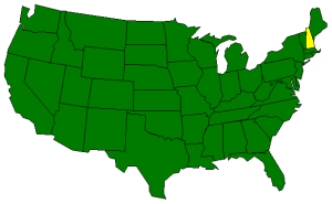
| Borders | New Hampshire is bordered by Canada on the north and by Massachusetts on the south. On the east, New Hampshire is bordered by the Atlantic Ocean and Maine and on the west, New Hamsphire is bordered by Vermont. | |
| Total area | New Hampshire covers 9,351 square miles, making it the 45th largest of the 50 states. | |
| Land area | 8,969 square miles of New Hampshire are land areas. | |
| Water area | 382 square miles of New Hampshire are covered by water. | |
| Highest point | The highest point in New Hampshire is is Mount Washington, at 6,288 feet above sea level. | |
| Lowest point | The lowest points in New Hampshire are at sea level where the state meets the Atlantic Ocean on its eastern border. | |
| Mean elevation | Between the highest point and the lowest point in New Hampshire, the mean elevation of the state of is 1,000 feet above sea level. | |
| Major rivers | The Connecticut River; the Pemigewasset River; the Merrimack River [ Upper | Lower ]; the Androscoggin River; and the Saco River. | |
| Major lakes | Lake Winnepesaukee; Newfound Lake; and Squam Lake | |
The Land
Known for its natural beauty, New Hamsphire features rugged mountains, clear blue lakes, and sandy lake and ocean beaches. All of these features are packed into one of the smallest states of the 50 states. New Hampshire ranks 46th in terms of size; 9,351 square miles.
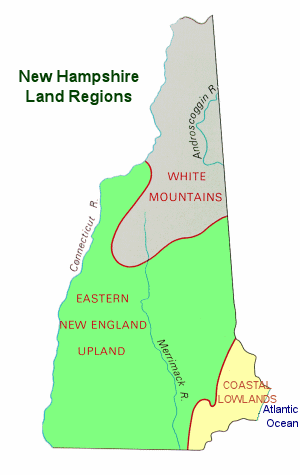
Contained within the Appalachian Highlands, the three primary geological features and landforms (physiographic regions) of New Hampshire are; the Coastal Lowlands, the Eastern New England Upland, and the White Mountain Region.
The Coastal Lowlands
The Coastal Lowlands characterize the southeastern section of the state where New Hampshire borders the Atlantic Ocean. With only 13 miles of coastline, the New Hampshire coastline is shorter than any other state that borders an ocean. The Coastal Lowlands extend from 15 to 20 miles into New Hamsphire. Sandy beaches line the coast and rivers and tidal wetlands extend inland. Great Bay is part of the Coastal Lowlands and thousands of waterfowl stop at the bay during their annual migrations.
The Eastern New England Upland
Most of southern New Hampshire is covered by the Eastern New England Upland, the region that runs from northern Maine south to eastern Connecticut. The New Hampshire section is comprised of 3 distinct areas; the Merrimack Valley, the Hills and Lakes Region, and the Connecticut River Valley.
The Merrimack Valley extends from the Massachusetts border north to central New Hampshire. The Merrimack River runs through this hilly landscape. The soil is fertile and fruits and hay are grown in this region. The valley is also home to New Hampshire's most prominent mill and factory cities and towns.
The Hills and Lakes region wraps around the Merrimack Valley region on the east, the north, and the west; from the border of Maine arcing northwest and then south almost reaching the border of Vermont. This area contains most of New Hampshire's major lakes, including its largest; Lake Winnipesaukee.
The Connecticut River Valley extends from north to south along the Connecticut River, New Hampshire's border with Vermont. The lowlands are comprised of fertile farmland and the hills are covered with hardwood forests.
The White Mountains
The White Mountains Region, north of the Eastern New England Upland, covers the northern portion of the state and consists of rugged mountains and narrow valleys. Mount Washington, the highest point in New Hamsphire and the highest point in New England, is part of the Presidential Range. It is 6,288 feet above sea level and home to some of the worst weather in the world. Five other peaks in the Presidential Range are over a mile in height. The Franconia Range includes Profile Mountain which formerly hosted the Old Man of the Mountain, a granite profile of an old man's face, near the peak.
The most northern portion of the region is characterized by heavily forested hills. The western section is populated with dairy and potato farms.
Climate
| Highest temperature | The highest temperature recorded in New Hampshire is 106° Fahrenheit (41°C). This record high was recorded on July 4, 1911 at Nashua. |
| Lowest temperature | The lowest temperature in New Hampshire, -47°F (-44°C), was recorded on January 29, 1934 on Mount Washington. |
| Average temperature | Monthly average temperatures range from a high of 82.6°F (28.1°C)degrees to a low of 9.0°F (-12.8°C). |
| Precipitation | Average yearly precipitation for New Hampshire, from 1971 to 2000, is shown on this chart from Oregon State University. |
New Hampshire experiences a humid continental climate (Koppen climate classification Dfa in southern areas and Dfb in the north), with warm, humid summers, cold, wet winters, and uniform precipitation all year. The climate of the southeastern portion is moderated by the Atlantic Ocean and averages relatively milder and wetter weather, while the northern and interior portions experience cooler temperatures and lower humidity. Winters are cold and snowy throughout the state, and especially severe in the northern and mountainous areas. Average annual snowfall ranges from 60 inches (150 cm) to over 100 inches (250 cm) across the state.[1]
Average daytime highs are in the mid 70s°F to low 80s°F (around 24-28 °C) throughout the state in July, with overnight lows in the mid 50s°F to low 60s°F (13-15 °C). January temperatures range from an average high of 34 °F (1 °C) on the coast to overnight lows below 0 °F (-18 °C) in the far north and at high elevations. Average annual precipitation statewide is roughly 40 inches (100 cm) with some variation occurring in the White Mountains due to differences in elevation and annual snowfall.
Extreme snow is often associated with a nor'easter, such as the Blizzard of '78 and the Blizzard of 1993, when several feet accumulated across portions of the state over 24 to 48 hours. Lighter snowfall of several inches occur frequently throughout winter, often associated with an Alberta Clipper.
New Hampshire, on occasion, is affected by hurricanes and tropical storms although by the time they reach the state they are often extratropical, with most storms striking the southern New England coastline and moving inland or passing by offshore in the Gulf of Maine. Most of New Hampshire averages fewer than 20 days of thunderstorms per year and an average of 2 tornadoes occur annually statewide.[2]
The National Arbor Day Foundation plant hardiness zone map depicts zones 3, 4, 5, and 6 occurring throughout the state [3] and indicates the transition from a relatively cooler to warmer climate as one travels southward across New Hampshire.Sources...
Carpenter, Allan and Provorse, Carl. The World Almanac® of the U.S.A.. Mahwah, N.J. An Imprint of K-III Reference Corporation, A K-III Communications Company. 1996.
New Hampshire - Population Finder - American FactFinder. U.S. Census Bureau. 2009. DD April 2009 <http://factfinder.census.gov/servlet/SAFFPopulation?_event=Search&Rank&_name=&Rank&_state=04000US33>
New Hampshire. Wikipedia, the free encyclopedia. 2009 23 April 2009 <http://en.wikipedia.org/wiki/New_Hampshire>
[1] Dellinger, Dan. Snowfall - Average Total in Inches. National Oceanic and Atmospheric Administration (NOAA). 2004. 25 May 2007.
[2] Annual average number of tornadoes 1953-2004. National Oceanic and Atmospheric Administration (NOAA). 25 May 2007.
[3] 2007 Arborday.org Hardiness Zone Map. National Arbor Day Foundation. 25 May 2007.
Additional Information
Geography Glossary: Houghton, Mifflen, Harcort School Publishers.
Glossary: National Weather Service glossary containing information on more than 2000 terms, phrases and abbreviations.
New Hampshire
by Rennay Craats
New Hampshire
by Joanne Mattern
New Hampshire (World Almanac Library of the States), by Joanne Mattern. 48 pages. Gareth Stevens Publishing (January 2003) Reading Level: Grades 4 - 6. In addition to an in-depth factual profile of New Hampshire in the form of a state Almanac, this book offers fascinating and lively discussions of the state's history, people, geography, government, economy, culture, and lifestyles. Includes a section on Notable People, a calendar of events, and enough primary source documents, time lines, maps, and other tools to make this unquestionably the best young adult reference material on New Hampshire available anywhere.
New Hampshire (A Guide to American States), by Rennay Craats. 32 pages. Weigl Publishers (December 2001) Reading level: Ages 9-12. Describes the history, geography, plants and animals, government, industry, people, and social life and customs of New Hampshire, one of the thirteen original colonies of the United States.
 Custom Search


