The Geography of Wisconsin
Click here for a few definitions.
| Longitude / Latitude |
Longitude: 86° 49'W to 92° 54'W
Latitude: 42° 30'N to 47° 3'N |
|
| Length x Width |
Wisconsin is about 310 miles long and 260 miles wide. |
|
Geographic Center
Explanation |
The
geographic center
of Wisconsin is located in Wood County,
9 miles SE of
Marshfield.
Longitude: 89° 45.8'W
Latitude: 44° 26.0'N |
|
| Borders |
Wisconsin is bordered by Minnesota and
Michigan on the north and by Illinois
on the south. On the east, Wisconsin is bordered by
Lake Michigan. On the west,
Wisconsin is bordered by Minnesota and Iowa. |
| Total Area |
Wisconsin covers 65,503 square miles, making it the 23rd largest of the
50 states. |
| Land Area |
54,314 square miles of Wisconsin are land areas. |
| Water Area |
11,190 square miles of Wisconsin are covered by water. |
| Highest Point |
The highest point in Wisconsin is
Timms Hill
at 1,951 feet above sea level. |
| Lowest Point |
The lowest point in Wisconsin is Lake Michigan at 581 feet above sea level. |
| Mean Elevation |
The Mean Elevation of the state of Wisconsin is 1,050 feet above sea level. |
| Major Rivers |
Wisconsin River,
Mississippi River,
St. Croix River, Chippewa River |
| Major Lakes |
Lake Michigan,
Lake Superior,
Lake Winnebago |
The Land |
|
Thousands of years ago, most of Wisconsin was visited by glaciers, scraping the tops off hills, leaving
rich earth deposits and leaving a land of beautiful lakes (15,000 of them) resting in fertile plains and valleys arranged
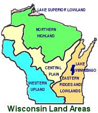
between rolling hills and ridges. This state can be divided into five geographical land areas; the Lake
Superior Lowland, the Eastern Ridges and Lowlands (Great Lakes Plains), the Northern Highland, or Superior
Upland, the Central Plain and the Western Upland.
Lake Superior Lowland: In northern Wisconisin, the
Lake Superior Lowland
slopes gradually upwards
toward the south from the shores of Lake Superior. This small area of flat plain extends about 5 to 20 miles
inland.
Northern Highland: Most of northern Wisconsin is characterized by
Northern Highland
geography.
This area, lying south of the Lake Superior Lowland, expands into about 1/3 of the sate. The Norther Highland
reaches its highest elevations in the north, sloping downward to the south. The Northern Highland
supports hundreds of small lakes and heavily forested hills.
Timms Hill,
the highest point in Wisconsin, is located in the Northern Highland.
Central Plain: South of the Northern Highland and curving across the central part of the state is
an area of
Central Plain.
In the southern portion of the Central Plain, the Wisconsin River has carved the beautiful scenic gorge,
Wisconsin Dells.
This is an area of buttes and mesas; an unexpected landscape for central Wisconsin.
Eastern Ridges and Lowlands: To the east of the Central Plain, the gently rolling hills of the
Eastern Ridges and Lowlands
area extends from Green Bay south to Illinios. This is the richest agricultural
region of Wisconsin where ice-age glaciers deposited earth over limestone ridges.
Western Upland: To the west of the Central Plain the
Western Upland
is characterized by limestone
and sandstone bluffs along the Mississippi River. The Western Upland extends along the Mississippi River
to the border of Illinios. The southwestern portion of the Western Upland was not touched by glaciers and
is an area that supports steeply sloped ravines and winding ridges.
( Wisconsin Close-up ) |
| Climate (All temperatures Fahrenheit) |
| Highest Temperature |
The highest temperature recorded in Wisconsin is 114°, Fahrenheit. This record high
was recorded on July 13, 1936 at
Wisconsin Dells. |
| Lowest Temperature |
The lowest temperature in Wisconsin, -55°, was recorded on February 4, 1996 at Couderay. |
| Average Temperature |
Monthly average temperatures range from a high of 82.8 degrees to a low of 5.4 degrees. |
| Climate |
Average yearly precipitation for Wisconsin, from 1971 to 2000, is shown on
this chart from Oregon State University. |
|