
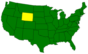
The Geography of Wyoming
Click here for a few definitions.
| Longitude / Latitude |
Longitude: 104° 3'W to 111° 3'W
Latitude: 41°N to 45°N |
|
| Length x Width |
Wyoming is about 360 miles long and 280 miles wide. |
|
Geographic Center
Explanation |
The
geographic center
of Wyoming is located in Fremont County, 58 miles ENE of Lander.
Longitude: 107° 40.3'W
Latitude: 42° 58.3'N |
|
| Borders |
Wyoming is bordered by Montana on the north and
Utah and Colorado on the south.
On the east, Wyoming is bordered by South Dakota and
Nebraska. On the west, Wyoming is bordered by
Idaho and Utah. |
| Total Area |
Wyoming covers 97,818 square miles, making it the 10th largest of the
50 states. |
| Land Area |
97,105 square miles of Wyoming are land areas. |
| Water Area |
714 square miles of Wyoming are covered by water. |
| Highest Point |
The highest point in Wyoming is
Gannett Peak,
in the Wind River Range, at 13,804 feet above sea level. |
| Lowest Point |
The lowest point in Wyoming is the Belle Fourche River at 3,099 feet above sea level. |
| Mean Elevation |
The Mean Elevation of the state of Wyoming is 6,700 feet above sea level making Wyoming the
second highest state just after Colorado. |
| Major Rivers |
Bighorn River, Green River, Belle Fourche River, Powder River, North Platte River |
| Major Lakes |
Yellowstone Lake, Glendo Reservoir, Bighorn Lake, Boysen Reservoir, Flaming Gorge Reservoir,
Seminoe Reservoir, Alcova Reservoir, Keyhole Reservoir |
The Land |
|
Essentially, Wyoming is one big plateau broken by many towering mountain ranges. Wyoming is a state where
the Great Plains meets the Rocky Mountains.
 |
Yellowstone National Park:
South Entrance Road |
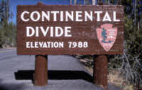
The Continental Divide cuts through Wyoming from the northwest to the south central border. Rivers east of
the Divide drain into the Missouri River Basin and eventually the Atlantic Ocean. The major rivers in the
east are the Platte, Wind, Big Horn and the Yellowstone rivers. To the west of the Continental Divide,
the rivers of Wyoming drain into the Columbia or Colorado River Basins into the Pacific Ocean. Wyoming's
major western rivers are the Snake River in northwest and the Green River to the south.
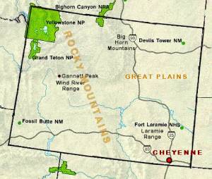
The state of Wyoming can be divided into three geographical land areas; the Great Plains, the Rocky Mountains
and the Intermontane Basins. Intermontane refers to the land between the mountains.
Great Plains: The eastern part of Wyoming is influenced by the Great Plains, part of the interior
plain that stretches from Canada through the United States to Mexico. The land of the Great Plains of Wyoming
is characterized by short-grass prairie and with cottonwoods and shrubs growing along the rivers in the area.
The Great Plains area receives little rainfall. In the northeast of Wyoming, along the border of
South Dakota the Black Hills spread into the state. About 1/3 of the Black
Hills area is located in Wyoming with the other 2/3 located in South Dakota. In this area, on the western
bank of the Belle Fourche River, the spectacular
Devils Tower National Monument
rises above the plains.
Rocky Mountains: Sweeping across most of the state of Wyoming from the north to the south is
a series of rugged Rocky Mountain ranges. Fronting the Great Plains in the north, are the
Big Horn Mountains.
Fronting the Great Plains in the south is the Laramie Range which extends into Wyoming from Colorado. A wide
Plateau lies between these two ranges.
An interesting formation found in southeastern Wyoming is a narrow strip of land, only about 100 yards wide, that rises gradually from the
flat plains into the Laramie Mountians. This slope, sometimes called the
"Gangplank"
is a corridor for major highways and railways and provides
a direct route from the Great Plains into the higher mountain areas of the state.
Beyond the Plateau, to the northwest, the Absaroka Range rises on the Eastern edge of Yellowstone Park. To
the south, in west central Wyoming, the Wind River Range presents some of the most rugged mountain territory
in the state. Nine of the peaks in the Wind River Range reach over 13,000 feet into the sky. The highest
point in Wyoming, Gannett Peak (13, 804 feet) is found in the Wind River Range. Just south of the Wind River
Ranges, the Granite Mountains turn eastward.
Along Wyoming's western border with Idaho, the beautiful Teton Mountains, tower over a mile above Jackson
Hole Valley. Also found along the border are the Gros Ventre, Salt River, Snake River, and Wyoming ranges. To the
south are the Medicine Bow and Sierra Madre ranges.
Intermontane Basins: Several relatively flat areas between Wyoming mountain ranges are part of
the Intermontane Basins. These areas are characterized by short grasses and lower brush. They are mostly
treeless and don't receive the amounts of rainfall that are found in the mountains. Major basins are the
Bighorn and Powder River Basins in the north, the Wind River Basin in central Wyoming and the Green River,
Great Divide, and Washakie Basins in the south.
The Great Divide Basin runs along the Continental Divide. The little rain that falls in this area
quickly soaks into the ground. An area of Wyoming, called the
Red Desert,
covers a part of the Great Divide
Basin and an area to the south of the basin. Plant life is very thinly dispersed, along with sagebrush,
in this area.
( Wyoming Close-up ) |
| Climate (All temperatures Fahrenheit) |
| Highest Temperature |
The highest temperature recorded in Wyoming is 115°, Fahrenheit. This record high
was recorded on August 8, 1983 at Basin. |
| Lowest Temperature |
The lowest temperature in Wyoming, -66°, was recorded on February 9, 1933 at Riverside R.S. |
| Average Temperature |
Monthly average temperatures range from a high of 87.1 degrees to a low of 11.9 degrees. |
| Climate |
Wyoming has the second highest mean elevation in the United States at 6,700 feet above sea level. The
climate is semiarid, but because of its topographical diversity, it is also varied. Annual precipitation
varies from as little as five inches to as much as 45 inches a year, some in the form of rain and some in
snow.
Because of its elevation, Wyoming has a relatively cool climate. Above the 6,000 foot level the temperature
rarely exceeds 100 F. Summer nights are almost invariably cool, though daytime readings may be quite high.
Away from the mountains, low July temperatures range from 50 to 60 F.
Average yearly precipitation for Wyoming, from 1971 to 2000, is shown on
this chart from Oregon State University. |
|


;)