


The Geography of Michigan
Click here for a few definitions.
| Longitude / Latitude |
Longitude: 82° 26' W to 90° 31' W
Latitude: 41° 41' N to 48° 15' N |
|
| Length x Width |
Michigan is 490 miles long and 240 miles wide at its most distant points. |
|
Geographic Center
Explanation |
The geographic center of Michigan is located in Wexford County, approximately 5 miles north-northwest of
Cadillac.
Longitude: 84° 56.3'W
Latitude: 45° 3.7'N |
|
| Borders |
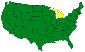
Michigan is a unique state in that it consists of two separate peninsulas into the Great Lakes.
Click here
for a Michigan Close-up.
The upper peninsula is bordered on the north by Lake Superior and on the south by
Lake Michigan and
Lake Huron.
The upper peninsula is bordered on the west by Wisconsin.
The lower peninsula rises between Lake Michigan and Lake Huron and
Lake Erie. It is bordered on
the west by Lake Michigan and on the east by Lake Huron and Lake Erie. The lower peninsula is bordered on the
south by Indiana and Ohio. |
| Total Area |
Michigan covers 96,810 square miles, making it the 11th largest of the
50 states and the largest state east of the Mississippi River. |
| Land Area |
56,809 square miles of Michigan are land areas. |
| Water Area |
40,001 square miles of Michigan are covered by water making Michigan the 2nd wettest
state behind Alaska. |
| Highest Point |
The highest point in Michigan is Mount Arvon, at 1,979 feet above sea level. |
| Lowest Point |
The lowest point in Michigan is 572 feet above sea level where Michigan meets Lake Erie. |
| Mean Elevation |
The Mean Elevation of the state of Michigan is 900 feet above sea level. |
| Major Rivers |
Detroit River, Grand River, Kalamazoo River, St. Clair River, St. Marys River |
| Major Lakes |
Lake Michigan, Lake Superior, Lake Huron, Lake Erie,
Lake St. Clair |
The Land |
| Michigan, one of the leading manufacturing states, is a leading tourist state as well. Touching on four
of the five Great Lakes, the two land areas of Michigan give the state a shoreline of 3,288 miles, second
in length only to Alaska. Michigan also supports over 11,000 lakes. Michigan's two separate land areas
are called the Upper Peninsula and the Lower Peninsula. They're connected by the five mile long
Mackinac Bridge.
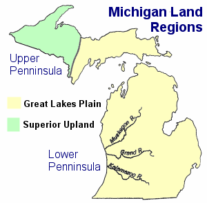 Two land regions characterize the Michigan landscape; the Superior Upland and the Great Lakes Plains.
The Great Lakes Plain: The Lower Peninsula is part of the Great Lakes Plains that stretch, along the
Great Lakes, from Michigan and Wisconsin to Ohio. The Lower Peninsula is fairly level but some low rolling hills
can be found in the south. To the north this changes to a northern tableland of hilly belts. The lowest point
in Michigan, along the shore of Lake Erie is found in the Lower Peninsula.
The Upper Peninsula is level with swampy areas in the east; part of the Great Lakes Plains.
Superior Upland: In the western part of the Upper Peninsula, the land achieves higher elevations and
the terrain becomes more rugged. The western area of the Upper Peninsula is referred to as the Superior Upland.
The Superior Upland runs along Lake Superior and into the Porcupine Mountains in northwestern Michigan. Mount
Arvon, the highest point in Michigan, is found on the Upper Peninsula.
( Michigan Close-up ) |
| Climate (All temperatures Fahrenheit) |
| Highest Temperature |
The highest temperature recorded in Michigan is 112°, Fahrenheit. This record high
was recorded on July 13, 1936 at Mio. |
| Lowest Temperature |
The lowest temperature in Michigan, -51°, was recorded on February 9, 1934 at Vanderbilt. |
| Average Temperature |
Monthly average temperatures range from a high of 83.1 degrees to a low of 14.0 degrees. |
| Climate |
Average yearly precipitation for Michigan, from 1971 to 2000, is shown on
this chart from Oregon State University. |
|


;)