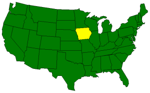
The Geography of Iowa
Click here for a few definitions.
| Longitude / Latitude |
Longitude: 89° 5' W to 96° 31' W
Latitude: 40° 36' N to 43° 30' N |
|
| Length x Width |
Iowa is 310 miles long and 200 miles wide. |
Geographic Center
Explanation |
The
geographic center
of Iowa is located in Story County, 5 miles NE of
Ames.
Longitude: 93° 23.1'W
Latitude: 41° 57.7'N |
| Borders |
Iowa is bordered by Minnesota in the north and by
Missouri in the south. Wisconsin and
Illinois are on the east and South Dakota and
Nebraska border Iowa on the west. |
| Total Area |
Iowa covers 56,276 square miles, making it the 26th largest of the
50 states. |
| Land Area |
55,875 square miles of Iowa are land areas. |
| Water Area |
401 square miles of Iowa are covered by water. |
| Highest Point |
The highest point in Iowa is on Sterler Farm, north of Sibley, in Osceola County and is
1,670 feet above sea level. The high point was officially named
Hawkeye Point in 1998. |
| Lowest Point |
The lowest point in Iowa is at the Mississippi River; 480 feet
above sea level. |
| Mean Elevation |
The Mean Elevation of the state of Iowa is 1,100 feet above sea level. |
| Major Rivers |
Cedar River,
Des Moines River,
Iowa River,
Mississippi River,
Missouri River |
| Major Lakes |
Lake Red Rock |
The Land |
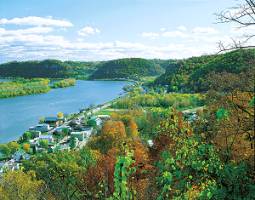 |
Mississippi River, Lansing
Courtesy: Iowa Tourism Office |
Between the Mississippi River on the east and the Missouri River on the west, Iowa is home to some of the
most fertile top soil in the world. Its land areas can be divided into three main regions; the Young Drift
Plains which cover most of the northern and central parts of Iowa, the Driftless Area parallel to the
Mississippi River in the northeast, and the Dissected Till Plains in the southern area of the state. The
fertile lands of Iowa makes the state the number one corn producer in the United States.
Young Drift Plains: Covering most of northern and central Iowa, the Young Drift Plains are mostly
flat, fertile lands. This land was covered by clay, sand, gravel, and rocks, called drift, left by glaciers
during the ice age. This drift became some of the most fertile topsoil in the world. Where the drift was not
spread evenly by the glaciers, lakes and swamps filled the hollows in the land.
Driftless Area: In northeatern Iowa, parallel with the Mississippi River, lies the Driftless Area.
This area was not flattened to the extent of the Young Drift Plains and is characterized by rugged hills and
cliffs. What drift that was deposited in this area has been blown or washed away. The soil is thin and
not suited to farming. The pine-forested hills are beautiful, however and great for outdoor recreation.
It is referred to as The Switzerland of America by Iowans.
Dissected Till Plains: The Dissected Till Plains stretch across the southern part of Iowa and
extend north, along the Missouri and Big Sioux rivers into northwestern Iowa. Ice age glaciers left
glacial "drift" consisting of clay, sand, gravel, and boulders intermingled. This deposit is called till. Over
thousands of years, rivers and streams cut into (disected) the terrain forming low, rolling hills and ridges.
Bluffs, 100 to 300 feet high formed from wind-blown soil, rise above the Missouri River.
( Iowa Close-up ) |
| Climate (All temperatures Fahrenheit) |
| Highest Temperature |
The highest temperature recorded in Iowa is 118°, Fahrenheit. This record high
was recorded on July 20, 1934 at Keokuk. |
| Lowest Temperature |
The lowest temperature in Iowa, -47°, was recorded on January 12, 1912 at Washta. |
| Average Temperature |
Monthly average temperatures range from a high of 86.2 degrees to a low of 6.3 degrees. |
| Climate |
Average yearly precipitation for Iowa, from 1971 to 2000, is shown on
this chart from Oregon State University. |
|
Sources:
The World Almanac of the U.S.A. by Allan Carpenter and Carl Provorse, Copyright © 1998
Robert E. Clark, Malcolm J. Rohrboug, "Iowa," Discovery Channel School, original content provided by World Book Online,
http://www.discoveryschool.com/homeworkhelp/
worldbook/atozgeography/i/280720.html, 08/14/01.
The United States Geological Survey Website
Maps.com http://www.maps.com
 |
|