
HOME
INTRO
SYMBOLS
ALMANAC
ECONOMY
GEOGRAPHY
STATE MAPS
PEOPLE
FORUM
NEWS
COOL SCHOOLS
STATE QUIZ
BOOK STORE
MARKETPLACE
STATE LINKS
GUESTBOOK
CONTACT US


Double click any word for definition.
Alaska Geography
[ Click here ] for a few definitions.
| Category | Information | |
|---|---|---|
| Latitude/Longitude | Latitude: 54° 40' N to 71° 50' N
Longitude: 130° W to 173° E |
 [ Alaska Base and Elevation Maps ] |
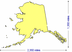
| Greatest distances | 1,350 miles: north to south 2,350 miles: west to east |
|
| Geographic center Disclaimer |
The geographic center (green arrow) of Alaska is located approximately 60 miles northwest (NW) of Mt. McKinley
Latitude: 63° 50'N Longitude: 152° W |
|
| Total area | Alaska covers 656,425 square miles, making it the largest of the 50 states and more than twice the size of Texas, the second largest state. | |
| Land area | Approximately 570,374 square miles of Alaska are land areas. | |
| Water area | Approximately 86,051 square miles of Alaska are covered by water. | |
| Coastline | Approximately 6,640 miles. | |
| Highest point | The highest point in Alaska is Mt. McKinley (Denali) at 20,320 feet above sea level. In fact, Mt. McKinley is the highest point in North America. | |
| Lowest point | The lowest point in Alaska is sea level where at the state meets the Pacific Ocean, the Bering Sea, and the Arctic Ocean. | |
| Mean elevation | Between the highest point and the lowest point in Alaska, the mean elevation of the state of is 1,900 feet above sea level. | |
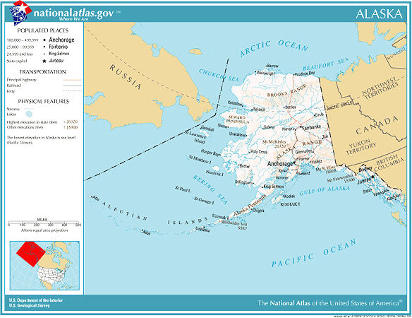
| Borders | Most of Alaska is surrounded by water. To the north is the Arctic Ocean, (the Beaufort Sea and the Chukchi Sea). To the south is the Gulf of Alaska and Pacific Ocean. To the west is the Bering Sea. On the east and south, Alaska borders Canada; Yukon Territory and British Columbia. | |
 |
||
| Major rivers |
A "river," defined as a "stream" by the United States Geological Survey's (USGS) Geographic Names Information System (GNIS), is a "Linear body of water flowing on the Earth's surface (anabranch, awawa, bayou, branch, brook, creek, distributary, fork, kill, pup, rio, river, run, slough)."  Yukon River and watershed Yukon RiverThe Yukon River, originates in Atlin Lake, Canada (British Columbia) and travels north through Canada's Yukon Territory. It enters Alaska near Eagle to the west of Fairbanks. It's the longest river in North America running 1,980 miles until it empties into the Bering Sea at the Yukon–Kuskokwim Delta in Alaska. The name, "Yukon," was derived from Indian words probably meaning "big river." The Yukon River is free of ice from June to October.  Kuskokwim River and watershed Kuskokwim RiverThe Kuskokwim River is the second longest river in Alaska. It flows from headwaters in the Kuskokwim Mountains and the Alaska Range that converge five miles east of Medfra. It flows for 702 miles, in a southwesterly course, before emptying into Kuskokwim Bay on the Bering Sea. The river's name loosely translates from the Yupik language as "big, slow-moving thing. 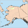 Coleville River and watershed Colville RiverThe Colville River originates in the De Long Mountains, above the Arctic Circle, and flows 350 miles to drain into the Beaufort Sea. The river was named for Edward Colville Griffith who surveyed the area prior to the purchase of the Alaska Territory by the United States in 1868, It's frozen for more than half the year serving as an ice highway in this far north area of Alaska. 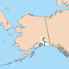 Copper River and watershed Copper RiverThe Copper River flows 300 miles, first north, then south from Copper Glacier, Mt. Wrangell, to empty into the Gulf of Alaska east of Cordova. It's named for the copper deposits found along the banks of the upper river. Noteworthy is the river's extensive delta and its massive wild salmon runs each year from mid-May through late-September. The Copper River Delta covers 700,000 acres, the largest wetlands on the North American Pacific coast. The spectacular salmon runs attract over 200 million fish for spawning each year. |
|
| Major lakes |
A "lake" is defined as a "Natural body of inland water (backwater, lac, lagoon, laguna, pond, pool, resaca, waterhole) by the United States Geological Survey's (USGS) Geographic Names Information System (GNIS). The major Alaska lakes are all found in the southern portions of the state. 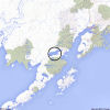 Iliamna Lake Iliamna LakeIliamna Lake is the largest lake in Alaska and the second largest lake, after Lake Michigan, the lies completely within the borders of the United States. It resides in southern Alaska on the Alaska Peninsula. It's approximately 80 miles long and 25 miles wide. According to G. C. Martin, U.S. Geological Survey (USGS), Iliamna is said to be "the name of a mythical great blackfish supposed to inhabit this lake, which bites holes in the bidarkas [kayaks] of bad natives." Iliamna Lake is known for its game fishing, its rainbow trout in particular. [ More... ]
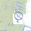 Aleknagik Lake Aleknagik Lake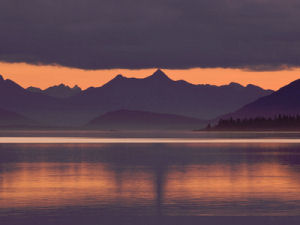 Sunset over Lake Aleknagik Photographs to purchase Aleknagik Lake is located in southwestern Alaska, about 40 miles northeast of Kulukak Bay on the Bering Sea. It's surrounded on three sides by Wood-Tikchik State Park and Togiak National Wildlife Refuge. It's approximately 20 miles long and 16 miles wide. The name of the lake, as well as the village that sits on its southeast shore, is said to be derived from a Yupik word meaning "wrong way home." It's said that Nushagak River residents returning from Kulukak Bay excursions to their homes upriver would sometimes become lost in the fog and might find themselves swept up the Wood River and into Aleknagik Lake by the tide. Aleknagik Lake and Wood River have served, historically as summer fishing camps. Not much has changed, though more of the activity may be purely recreational. The river and lake are ice-free from June to mid-October, though fog and low clouds may hinder access to the area in July and August. [ More... ] 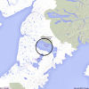 Becharof Lake Becharof LakeBecharof Lake is located on the Alaska Peninsula, 23 miles southeast of Egegik on Egegik Bay off Bristol Bay. It's bordered on the northeast by the Becharof National Wildlife Refuge. Becharof Lake is approximately 37 miles long and 15 miles wide. It's the second largest lake, after Iliamna, in Alaska. It was named in 1868 by W.H. Dall, US Coast and Geodetic Survey (USC&GS), after Russian navigator Dmitry "Bocharov," Imperial Russian Navy (IRN), who visited Kodiak in 1788. Known as a "salmon factory" Becharof Lake serves as a nursery for the world's second largest sockeye salmon run providing, along with its tributaries, up to six million adult salmon to the Bristol Bay fishery each year. [ More... ] 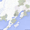 Lake Clark Lake ClarkAbout 42 miles long and eight miles wide, Lake Clark can be found in southern Alaska, in the Alaska Range, and within the Lake Clark National Park & Preserve. It's about two miles northeast of Nondalton and 40 miles west of Cook Inlet. The lake was named after John W. Clark, "chief of the Nushagak trading post in 1891 and discoverer of the lake." It's said that John Clark was the first American non-Native to view the lake. The Dena'ina Athabascan name is Qizjeh Vena which means "place where people gather lake." Recreational wilderness outdoor activity, backpacking, hiking, kayaking, and rafting, is the Lake Clark hallmark. In the fall, Lake Clark and the surrounding lakes and rivers are filled with spawning sockeye (red) salmon. [ More... } 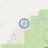 Lake Minchumina Lake MinchuminaLake Minchumina is located 66 miles north-northwest of Mt. McKinley. It's approximately nine miles long and six miles wide. In 1899, Lieutenant J. S. Herron reported that the name of the lake was derived from a Tanana Indian name meaning "clear lake." Another proposal has it that the name comes from Athabascan words Menchu Mene' or Menhchu Mene'. To the Athabascan Indians, Minchumina and Minkhotana meant the "lake people." Historically Lake Minchumina was central as a portage between the waterways of the Yukon-Tanana and Kuskokwim Rivers. Its location was important as a midway point for sled trail mail transportation in the 1920s and 1930s, and for airplane transportation between Fairbanks and McGrath. [ More... ] |
|
The Land
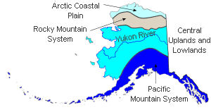
Alaska Land Regions
Alaska's geography can be categorized into four main areas including two mountain ranges, a central plateau, and the Arctic slope or coastal plain.
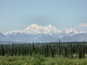
Mount McKinley (Denali), Alaska Range
Photograph: U.S. Fish and Wildlife Service
Prints, Photographs and Posters
Pacific Mountain System:
In the south and southeast, the Pacific Mountain system is a major feature and is divided into many subdivisions. In general, the Pacific Mountain System runs from the Aleutian Islands down through south central Alaska down the Pacific coast to southern California. In southeast Alaska, a strip of land about 400 miles long and about ten to 150 miles wide comprises what is known as the Alaska Panhandle bordering the Pacific Ocean and the Gulf of Alaska. The Pacific Mountain System includes, from the south, the Saint Elias Range, the Wrangell Mountains, the Chugach Mountains and the Kenai Mountains (West to the Kenai Peninsula and Kodiak Island), the Talkeetna Mountains, and the Alaska Range home of Mt. McKinley.
Extending southwest from the southern Alaska mainland and the Alaska Range, the Alaska Peninsula and the Aleutian Islands are supported by the Aleutian Mountain Range. The Aleutians include 14 large islands and about 55 small islands. The largest islands are Unimak, Unalaska, and Umnak. The Aleutian Range extends 1,600 mile, from Mount Spurr, across Cook Inlet from Anchorage, to Attu Island near the Asian continent and contains many active volcanoes. This range is home to the Valley of Ten Thousand Smokes, created when Novarupta erupted in 1912. The Valley of Ten Thousand Smokes was named for the numerous fumaroles in the area. Fumaroles are holes in the earth that release hot gas steam into the air.
Within the Pacific Mountain System are two distinct lowland areas; the Copper River Basin and the Susitna-Cook Inlet lowland. The Copper River Basin lies between the Chugach and Wrangell mountains and during the ice age was once the site of a large lake. Today it is a forested woodland. The Susitna-Cook Inlet extends north and east from Anchorage and is mostly forested. It also includes the fertile farmland known as the Matanuska Valley.
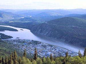
Dawson City, Alaska on the Yukon River
Photographs, Prints and Posters
Central Uplands and Lowlands:
This area is sandwiched between the Alaska Range of the Pacific Mountain System in the south and the Brooks Range of the Rocky Mountain System of Alaska in the north. Its geography makes up the largest land area in Alaska. Bordered on the west by Canada, the Central Uplands and Lowlands region extends westward to include the Seward Peninsula and the Kuskokwim River area of southwestern Alaska. The Central Upland and Lowlands area is marked by low, rolling hills and swampy river valleys such as those of the Koyukuk, Kuskokwim, Tanana, and Yukon rivers.
Rocky Mountain System of Alaska:
North of the Central Uplands and Lowlands area is the Rocky Mountain System of Alaska. This area is comprised of the Brooks Range and the Brooks Range foothills. The Brooks Ranges is comprised of glacier-made mountain peaks that rise to 9,000 feet above sea level in the east with lower elevations in the west.
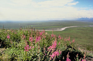
Arctic Coastal Plain, Alaska
Photograph: U.S. Fish and Wildlife Service
Photographs, Prints and Posters
Arctic Coastal Plain:
The northernmost geographic area of Alaska is called the Arctic Coastal Plain.
This area lies north of the Rocky Mountain System and slopes gradually toward the Arctic Ocean. This is the land of permafrost (Permanently frozen ground) and no trees can manage to grow in this area. The surface of the ground does thaw enough in the spring to allow the growth of grass and wildflowers however. This area is called the tundra.
[ More Alaska ]
Climate
Highest temperature
The highest temperature recorded in Alaska is 100°, Fahrenheit. This record high was recorded on June 27, 1915 at Fort Yukon.
Lowest temperature
The lowest temperature in Alaska, -80°, Fahrenheit, was recorded on January 23, 1971 at Prospect Creek Camp.
Average temperature
Monthly average temperatures range from a high of 71.8 degrees to a low of -21.6 degrees Fahrenheit.
Precipitation
Mean yearly precipitation for Alaska, from 1961 to 1990, is shown on this chart from Oregon State University.
Sources...
Carpenter, Allan & Provose, Carl. The World Almanac® of the U.S.A.. World Almanac Books . Mahwah, N.J., 1996.
Claus-M. Naske and F. Patrick Fitzgerald, "Alaska," World Book Online Americas Edition, http://www.worldbookonline.com/wbol/wbPage/na/ar/co/010640, August 14, 2001.
Alaska. A. Chicago: World Book, Inc., 1988. 288. Print.
The United States Geological Survey Website
"Yukon River." Wikipedia, the free encyclopedia. Wikipedia, the free encyclopedia, 08 June 2013. Web. 28 Jul 2013.
"Feature Detail Report for: Yukon River." Geographic Names Information System (GNIS). U.S. Geological Survey. Web. 28 Jul 2013.
"Kuskokwim River." Wikipedia, the free encyclopedia. Wikipedia, the free encyclopedia, 03 June 2013. Web. 29 Jul 2013.
"Feature Detail Report for: Kuskokwim River." Geographic Names Information System (GNIS). U.S. Geological Survey. Web. 29 Jul 2013.
"Colville River (Alaska)." Wikipedia, the free encyclopedia. Wikipedia, the free encyclopedia, 25 February 2013. Web. 29 Jul 2013.
"Copper River." Wikipedia, the free encyclopedia. Wikipedia, the free encyclopedia, 25 February 2013. Web. 29 Jul 2013.
"Iliamna Lake." Wikipedia, the free encyclopedia. Wikipedia, the free encyclopedia, 25 February 2013. Web. 30 Jul 2013.
"Feature Detail Report for: Iliamna Lake." Geographic Names Information System (GNIS). U.S. Geological Survey. Web. 30 Jul 2013.
"Aleknagik Lake." Wikipedia, the free encyclopedia. Wikipedia, the free encyclopedia, 25 February 2013. Web. 30 Jul 2013.
"Feature Detail Report for: Aleknagik Lake." Geographic Names Information System (GNIS). U.S. Geological Survey. Web. 30 Jul 2013.
"Becharof Lake." Wikipedia, the free encyclopedia. Wikipedia, the free encyclopedia, 25 February 2013. Web. 30 Jul 2013.
"Feature Detail Report for: Becharof Lake." Geographic Names Information System (GNIS). U.S. Geological Survey. Web. 30 Jul 2013.
"Lake Clark (Alaska)." Wikipedia, the free encyclopedia. Wikipedia, the free encyclopedia, 25 February 2013. Web. 30 Jul 2013.
"Feature Detail Report for: Lake Clark." Geographic Names Information System (GNIS). U.S. Geological Survey. Web. 30 Jul 2013.
"Lake Minchumina, Alaska." Wikipedia, the free encyclopedia. Wikipedia, the free encyclopedia, 25 February 2013. Web. 30 Jul 2013.
"Feature Detail Report for: Minchumina Lake." Geographic Names Information System (GNIS). U.S. Geological Survey. Web. 30 Jul 2013.
Green, Steven, and Nathan Blackburn. "Lake Minchumina Area History." National Park Service. U.S. National Park Service. Web. 8 Aug 2013. .


Sponsored Content
NETSTATE.COM is a Trademark of NSTATE, LLC.
Copyright © by NSTATE, LLC. All rights reserved.
No copyright is claimed on non-original or licensed material.
Support NETSTATE
Site designed exclusively for NETSTATE.COM by NSTATE, LLC
