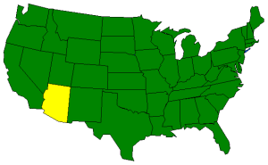
The Geography of Arizona
Click here for a few definitions.
| Longitude / Latitude |
Longitude: 109° 3' W to 114° 50' W
Latitude: 31° 20' N to 37° N |
|
East to West
North to South |
337 miles: greatest distance East to West.
389 miles: greatest distance North to South. |
Geographic Center
Explanation |
The
geographic center
of Arizona is located in Yavapai County, 55 miles ESE of Prescott.
Longitude: 111° 47.6'W
Latitude: 34°1 8.5'N |
| Borders |
Arizona is bordered by Utah to the north. In the south,
Arizona shares an international border with Mexico. On the east is New Mexico
and on the west is Nevada and California. |
| Total Area |
Arizona covers 114,006 square miles, making it the sixth largest of the
50 states. |
| Land Area |
113,642 square miles of Arizona are land areas. |
| Water Area |
Only 364 square miles of Arizona are covered by water making Arizona a pretty dry state
and just a little wetter than New Mexico and Wyoming. |
| Highest Point |
The highest point in Arizona is
Humphreys Peak,
northwest of Flagstaff, at 12,633 feet above sea level. |
| Lowest Point |
The lowest point in Arizona is the
Colorado River, only 70 feet
above sea level. |
| Mean Elevation |
The Mean Elevation of the state of Arizona is 4,100 feet above sea level. |
| Major Rivers |
Colorado River,
Little Colorado River, Gila River, Bill Williams River |
| Major Lakes |
Lake Mead,
Lake Havasu,
Lake Mohave,
Theodore Roosevelt Lake, San Carlos Lake, Lake Powell |
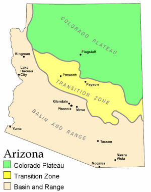
The Land |
| It's easy to think of Arizona as one big desert but, in fact, more than half of the state consists
of mountain and plateau areas and the largest Ponderosa Pine forest in the United States is found in the
Grand Canyon State. Arizona can be divided into three major land areas; the Colorado plateau, the Transition
Zone and the Basin and Ridge Region.
The Colorado Plateau: The
Colorado Plateau covers the northern
2/5 of the state of Arizona. This area is characterized by a broad, mostly flat, level land interrupted by occasional
soaring mountains and deep canyons. The Colorado River runs through the Colorado Plateau carving the deepest
canyon in the area, the Grand Canyon. Other notable
canyons, cut by tributaries of the Colorado River, are the
Canyon de Chelly and
Oak Creek Canyon. The highest point in Colorado is also located in the Colorado Plateau area.
Humphreys Peak climbs 12,633 feet above sea
level near Flagstaff. Some of the mountains are forested but the area is also marked by dry desert areas.
Monument Valley lies in the
northeast Colorado Plateau Region along the Utah border. Monument Valley is
an area of steep buttes, mesas and pinnacles standing defiantly above a flat plain. 10,000,000 years of
erosion have created a breathtaking landscape.
Black Mesa, one of
the largest geological formations in Arizona is found on the Colorado Plateau along with the
Painted Desert
and the Petrified Forest.
The southern edge of the Colorado Plateau is bordered by the
Mogollon Rim, a steep wall
almost 2,000 feet high in some places, that runs from central Arizona to the Mogollon Mountains in
New Mexico.
The Transition Zone: Just south of the Colorado Plateau and north of the Arizona Basin and Ridge
Region lies the aptly named Transition Zone. This narrow strip of land is characterized by a rugged series
of mountain ranges and valleys. The Mazatzal, Santa Maria, Sierra Ancha, and
White mountain ranges are found in the Transition
Zone along with the Salt River Canyon.
The Basin and Ridge Region: South of the Transition Zone, and occupying a small strip of land along
the western border with California, the Basin and Ridge Region of Arizona
is characterized by mountain ranges running from the northwest in a southeasterly direction. These mountain
ranges, with names like Chiricahua, Gila, Huachuca, Hualapai, Pinaleno, Santa Catalina, Santa Rita, and Superstition are separated
by low fertile valleys. When there is enough water, these valleys are capable of sustaining crops such as lettuce, cotton, citrus and
melons.
( Arizona Close-up ) |
| Climate (All temperatures Fahrenheit) |
| Highest Temperature |
The highest temperature recorded in Arizona is 128°, Fahrenheit. This record high
was recorded on June 29, 1994 at Lake Havasu City. |
| Lowest Temperature |
The lowest temperature in Arizona, -40°, was recorded on January 7, 1971 at Hawley Lake. |
| Average Temperature |
Monthly average temperatures range from a high of 105.0 degrees to a low of 38.1 degrees. |
| Climate |
Average yearly precipitation for Arizona, from 1971 to 2000, is shown on
this chart from Oregon State University. |
|