The Geography of Virginia
Click here for a few definitions.
| Longitude / Latitude |
Longitude: 75° 13'W to 83° 37'W
Latitude: 36° 31'N to 39° 37'N |
|
| Length x Width |
Virginia is about 430 miles long and 200 miles wide. |
|
Geographic Center
Explanation |
The
geographic center
of Virginia is located in Buckingham County, 5 miles SW of Buckingham.
Longitude: 78° 33.8'W
Latitude: 37° 29.3'N |
|
| Borders |
Virginia is bordered by West Virginia and
Maryland on the north and by North Carolina
and Tennessee on the south. On the east, Virginia is bordered
by Maryland and the
Atlantic Ocean.
On the west, Virginia is bordered by West Virginia and
Kentucky. |
| Total Area |
Virginia covers 42,769 square miles, making it the 35th largest of the
50 states. |
| Land Area |
39,598 square miles of Virginia are land areas. |
| Water Area |
3,171 square miles of Virginia are covered by water. |
| Highest Point |
The highest point in Virginia is Mount Rogers at 5,729 feet above sea level. |
| Lowest Point |
The lowest point in Virginia is sea level where Virginia meets the
Atlantic Ocean in the east. |
| Mean Elevation |
The Mean Elevation of the state of Virginia is 950 feet above sea level. |
| Major Rivers |
James River, Rappahannock River, Potomac River, Shenandoah River |
| Major Lakes |
Atlantic Intracoastal Waterway, Gathright Dam (Lake Moomaw), John H. Kerr Reservoir,
John W. Flannagan Reservoir, Pound Lake, Philpott Lake |
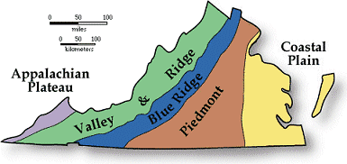
The Land |
|
Virginia, a southern state on the
Atlantic Ocean, can be divided
into five geographical regions; the Atlantic Coastal Plain, the Piedmont, the Blue Ridge, the Appalachian
Ridge and Valley Region, and the Appalachian Plateau.
Atlantic Coastal Plain: The Atlantic Coastal Plain runs from north to south along the
Atlantic Ocean. This area of
lowlands stretches about 100 miles inland and is covered with salt marshes and swamps.
Its often called the Tidewater because of the flow of water up and down the coastal inlets and bays as the
tide moves in and out. The Atlantic Coastal Plain is divided into a mainland in the west and a pennisula,
called the East Shore, by Chesapeake Bay.
Piedmont: To the west of the Atlantic Coastal Plain is the Piedmont, Virginia's largest
geographical land region. Sloping gradually upward from elevations of 200 to 300 feet above sea level in the
east to 800 to 900 feet above sea level in the west, the rolling plain of the Virginia Piedmont covers most
of central Virginia. About 40 miles wide in the northeast, the Piedmont expands to about 140 miles wide at
the North Carolina Border. The rivers and streams of the Piedmont generally flow in a southeasterly
direction, breaking into low waterfalls at the "fall line" where the Piedmont meets the Atlantic Coastal
Plain.
Blue Ridge: To the west of the Piedmont, lies the Blue Ridge. Northeast of
Roanoke, Virginia, the
Blue Ridge rises steeply from the Piedmont in the east and the Appalachian Ridge and Valley Region in the
west. It is the main eastern mountain range of the Appalachian Mountains. South of
Roanoke, the Blue
Ridge expands into a plateau with valleys, deep ravines, and the highest peaks in Virginia.
Mount Rogers,
the highest point in Virgina, is located in the Blue Ridge south of
Roanoke.
Appalachian Ridge and Valley Region: Extending southwest to northeast along Virginia's western
border is the Appalachian Ridge and Valley Region. The Great Valley, sometimes called the Valley of
Virginia, lies against the Blue Ridge in the east. Actually, the Great Valley is a series of valleys
divided by mountains. The largest and most well-known of these valleys is the Shenandoah Valley. The
Appalachian Ridge and Valley Region is riddled with caverns carved into the abundant limestone.
Appalachian Plateau: In the far southwestern portion of Virginia lies the Appalachia Plateau. This
plateau extends into Kentucky as the Cumberland Plateau. Covered with rivers, streams, and forests, the
Appalachian Plateau averages about 2,000 feet above sea level.
( Virginia Close-up ) |
| Climate (All temperatures Fahrenheit) |
| Highest Temperature |
The highest temperature recorded in Virginia is 110°, Fahrenheit. This record high
was recorded on July 15, 1954 at Balcony Falls. |
| Lowest Temperature |
The lowest temperature in Virginia, -30°, was recorded on January 25, 1985 at Mountain Lake Biological Station. |
| Average Temperature |
Monthly average temperatures range from a high of 88.4 degrees to a low of 26.2 degrees. |
| Climate |
Average yearly precipitation for Virginia, from 1971 to 2000, is shown on
this chart from Oregon State University. |
|