Return to NETSTATE.COM home page.

|| HOME
|| INTRO
|| SYMBOLS
|| ALMANAC
|| ECONOMY
|| GEOGRAPHY
|| STATE MAPS
|| PEOPLE
|| GOVERNMENT
|| FORUM
|| NEWS
|| COOL SCHOOLS
|| STATE QUIZ
|| BOOK STORE
|| MARKETPLACE
|| STATE LINKS
|| GUESTBOOK
|| CONTACT US

Oklahoma State Flag Oklahoma

Bookmark and Share

The Geography of Oklahoma

Click here  for a few definitions.

Longitude / Latitude Longitude: 94° 29'W to 103°W
Latitude: 33° 35'N to 37°N
Oklahoma map
Oklahoma base and elevation maps
Greatest Length x Width 478 miles, east to west and 231 miles north to south.  
Geographic Center
Explanation
The geographic center of Oklahoma is located in Oklahoma County, 8 miles N of Oklahoma City.
Longitude: 97° 39.6'W
Latitude: 35° 32.2'N
 
Borders Oklahoma is bordered by Colorado and Kansas on the north. On the south, Oklahoma is bordered by Texas. On the east, Oklahoma is bordered by Missouri and Arkansas and on the west, Oklahoma is bordered by New Mexico and Texas.
Total Area Oklahoma covers 69,903 square miles, making it the 20th largest of the 50 states.
Land Area 68,679 square miles of Oklahoma are land areas.
Water Area 1,224 square miles of Oklahoma are covered by water.
Highest Point The highest point in Oklahoma is Black Mesa at 4,973 feet above sea level.
Lowest Point The lowest point in Oklahoma is Little River at 289 feet above sea level.
Mean Elevation The Mean Elevation of the state of Oklahoma is 1,300 feet above sea level.
Major Rivers Arkansas River, Canadian River, Red River
Major Lakes Lake Texoma, Eufaula Lake, Lake Hudson, Lake O' the Cherokees, Gibson Lake, Oologah Lake, Keystone Lake

The Land

Oklahoma Land Regions
Oklahoma is a land of flat, fertile plains and low hills. Oil and natural gas wells can be seen thoughout much of the state. Oklahoma's plains also host large herds of cattle and vast wheat fields. The geographical landscape of 
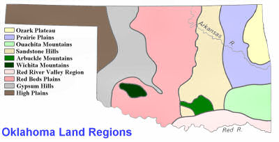
Oklahoma is comprised of 10 separate land regions.

The Ozark Plateau, in the northeastern part of the state, is an extension of the Missiouri and Arkansas landscape. It's marked by rivers with steep valley walls separated by broad flat areas.

West and south of the Ozark Plateau lies the region known as the Prairie Plains. This area produces most of the state's coal and a great deal of oil. Cattle graze on the Prairie Plains and farms in the Arkansas River Valley, east of Muskogee, produce spinach, beans, and carrots.

On the border of Arkansas, in the southeastern part of Oklahoma, are the Ouachita Mountains. These sandstone ridges, running east to west, form the roughest land in Oklahoma. Spring-fed streams run through narrow valleys between the ridges.

In the north central part of Oklahoma, extending south from the Kansas border to the Red River, is the Sandstone Hills Region. The Sandstone Hills are from 250 to 400 feet high. Some are covered with Blackjack and Post Oak forests. It was in this region that early oil development commenced in Oklahoma.

The Arbuckle Mountains comprise an area of about 1,000 square miles in south-central Oklahoma. The low mountains rise about 600 to 700 feet above the plains. Unusual rock formations have been created by erosion in the mountains. The area is used for cattle grazing.

The Wichita Mountains are found in southwestern Oklahoma.

The Red River Valley Region, in southern Oklahoma along the Texas border, is characterized by rolling prairie. Some forested hills can also be found in the area. The soil is sandy and fertile. Cotton, peanuts, and vegetables are grown in this region.

To the west of the Sand Hills, are the Red Beds Plains. The largest land region in Oklahoma, the Red Beds Plains stretch from the Kansas border in the north, south through the center of the state. The Red Beds Plains slope upward from east to west. In the east are some forested areas. In the west the region is covered with grass.

The Gypsum Hills lie west of the Red Beds Plains and extend north to the High Plains in the northwestern part of Oklahoma. The Gypsum Hills are low (150 to 200 feet) hills capped with 15 to 20 foot layers of gypsum. The Gypsum Hills sparkle in the sunlight because of their gypsum content and, because of this, are sometimes called the Glass Hills.

The High Plains, in northwestern Oklahoma, are level grasslands. The High Plains rise from about 2,000 feet above sea level in the east to 4,973 feet above sea level at Black Mesa in the west. This region includes the Oklahoma Panhandle, the strip of land 166 miles long and only 34 miles wide between Colorado and Kansas in the north and Texas in the south.

( Oklahoma Close-up )

Climate (All temperatures Fahrenheit)
Highest Temperature The highest temperature recorded in Oklahoma is 120°, Fahrenheit. This record high was recorded on July 26, 1934 at Tishomingo.
Lowest Temperature The lowest temperature in Oklahoma, -27°, was recorded on January 18, 1930 at Watts.
Average Temperature Monthly average temperatures range from a high of 93.9 degrees to a low of 24.8 degrees.
Climate Average yearly precipitation for Oklahoma, from 1971 to 2000, is shown on this chart from Oregon State University.
Sources:
The World Almanac of the U.S.A. by Allan Carpenter and Carl Provorse, Copyright © 1998
H. Wayne Morgan and Keith D. Harries, "Oklahoma," World Book Online Americas Edition, http://www.worldbookonline.com/wbol/wbPage/na/ar/co/400980, August 15, 2001.
The United States Geological Survey Website
Maps.com http://www.maps.com
To Ohio geography. To Oregon geography.

[ HOME || INTRO || SYMBOLS || ALMANAC || ECONOMY || GEOGRAPHY || STATE MAPS || PEOPLE || GOVERNMENT ]
[ FORUM || NEWS || COOL SCHOOLS || STATE QUIZ || BOOK STORE || MARKETPLACE || STATE LINKS ]
|| GUESTBOOK || CONTACT US || PRIVACY STATEMENT ]

Site designed exclusively for NETSTATE.COM by NSTATE
United States Flag


NETSTATE.COM is a Trademark of NSTATE, LLC.
Copyright © 2001- by NSTATE, LLC. All rights reserved.
No copyright is claimed on non-original or licensed material.
Support NETSTATE

Top