|
Hawai'i is the only state that is not part of the North American continent. It is also the southernmost of the states,
lying about as far south as central Mexico.
Hawai'i is actually a chain of 132 islands, each of which is the top of a submerged volcanic mountain, that can be
divided into three land groups.
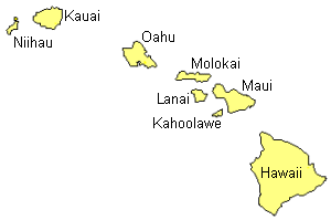
Group 1 consists of the eight main islands, the islands we usually think of when we think of Hawai'i. All of the main
islands, with the exception of
Kahoolawe,
are inhabited.
The remaining 124 islands in groups 2 and 3, only about three square miles in total land area, are not fit for human habitation.
Group 2 consists of the middle islands, tiny islands (islets) of rock.
Group 3 consists of the islands in the northwest, comprised of coral and sand.
The Main Islands
Some of the coastline is comprised of tall cliffs rising straight up
from the waters edge. In some places, large rocks of lava protrude from the water
along the shore. Most of the beaches on the islands serve up beautiful white sand.
Some beaches are covered with black sand, formed when molten lava met the ocean.
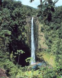 |
Akaka Falls, Hawaii
Photo by John Bortniak, NOAA Corps |
Hawai`i: Hawaii is the largest of the habitable Hawaiian islands and covers
4,038 square miles. This island was formed by five volcanoes, two of which are
still active.
Kohala
is on the northern side of the island. Hualalai
is in the west. Mauna Kea
and Mauna Loa are toward the center of the island.
Kilauea
is located on the eastern side of Mauna Loa. Mauna Kea, at 13,796 feet above sea level, is the highest point in
the state. Mauna Loa and Kilauea are still active volcanoes and erupt intermittently, sometimes spewing fiery
lava streams flowing down the mountains to the sea.
The north and southeastern coast of Hawaii is protected by high cliffs with silvery waterfalls falling over the edge and into the ocean below.
Take a virtual field trip of Hawai`i.
Maui: Maui was formed by two volcanoes and is often called
the Valley Island because of the many canyons that cut into the two mountains.
A low isthmus passes between the two mountains creating a fertile area for
growing sugar cane. Haleakala,
the highest point on Maui, also contains the world's largest dormant volcanic crater, at least for now.
Haleakala is considered active and is expected to erupt sometime within the next 200 years.
Take a virtual field trip of Maui.
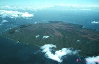 |
Kaho`olawe Island
Photo
by Jack Lockwood
U.S. Geological Survey
March 31, 1984 |
Kaho`olawe: Kaho`olawe
is a small, uninhabited island next to Maui. It is dry and windswept. Take a
field
trip to the island on a small fishing boat.
Moloka`i: The island of Moloka`i can be roughly divided into three regions
according to its physical features. The eastern region is covered with rugged
mountains and canyons. The west is a dry plateau. The central area is a fertile
plain suitable for growing various crops.
Take a virtual field trip of Moloka`i.
Lana`i: Is Pineapple growing country, with 98% of the land owned by the
makers of Dole pineapple products.
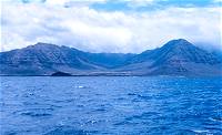 |
Western shore of O`ahu
Waianae Range
Courtesy: National Oceanic &
Atmospheric Administration |
O`ahu: O`ahu consists of two mountain ranges; the
Koolau Range in the east and
the Waianae Range in the west. The valley between these two mountain ranges consists of a fertile, rolling
plain and support many sugar and pineapple plantations. A most notable landmark, is the 760-foot extinct
volcanic crater, known as Diamond Head, located on the southeastern end of the island at the end of Waikiki.
Take a virtual field trip of O`ahu.
View this map of
O`ahu from the Naval Pacific Meteorology and Oceanography Center.
Kaua`i: In the center of the island is Kawaikini Peak, rising 5,170 feet and
Mount Waialeale, rising
5,080 feet. Mount Waialeale is the rainiest spot on earth, averaging 460 inches
of rain a year, and contributing to this island's nickname; the Garden Island. Many streams flow from these
mountains to the sea through canyons in the volcanic rock. Waimea canyon has colorful rock walls that
are 2,857 feet high. On the northwestern coast are rugged cliffs that make it impossible to build a
road around the whole island.
Take a virtual field trip of Kaua`i.
You may
view this map
provided by the Hawaii Geographic Information Coordinating Council.
Ni`ihau: Niihau
is a private island owned by the Robinson family of Kaua'i. It is nicknamed "The Forbidden Island." The island is a semi-arid island and the
climate is dry, though several lakes provide fresh water.
( Hawaii Close-up ) |


;)
;)