|
The Highlands of Arkansas are in the north and western part of the state. The Ozark Plateau and the
Ouachita mountains are located here. The Lowlands of Arkansas lie to the south and the east. Arkansas
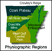
can be divided into five main land regions; the Ozark Plateau, the Arkansas Valley, the Ouachita Mountains,
the Mississippi Alluvial Plain (referred to as the Mississippi Embayment on the map to the left), and the West Gulf
Coastal Plain.
Ozark Plateau: The Ozark Plateau lies in the northwestern and north
central part of Arkansas. Also covering parts of Missouri,
Illinois and Oklahoma, the Ozark Plateau is an
area of rugged hills and deep valleys. Much of the area, sometimes referred to as the Ozark Mountains, is
heavily forested. To the south, river gorges up to 1,500 feet deep, carved by swiftly flowing streams, cut
through the plateau. The steep hills in this area of the Plateau are called the
Boston Mountains. The
Boston Mountains give way to the Arkansas Valley to the south of the Plateau. The Ozark Plateau is home to
Mammoth Springs,
one of the largest springs in the United States. Visit
The Ozarks by Carmen Borne for more
information about the Ozark Plateau.
Arkansas Valley: Separating the Ozark Plateau to the north and the Ouachita Mountains to the south is the Arkansas Valley.
Cutting through the Arkansas Valley, is the Arkansas River, the largest river in the state. Though the elevation of the Arkansas Valley
is generally lower than the Ozark Plateau to the north and the Ouachita Mountains to the south, a few mountains dot the landscape.
Magazine Mountain, the highest point in Arkansas, is found in the Arkansas Valley. Visit
River Valley from EncyclopediaOfArkansas .
Ouachita Mountains: One of two major ranges in the United State that runs east to west, the
Ouachita Mountains
consist of parallel ridges and valleys that run from eastern Oklahoma to
central Arkansas. The
Ouachita River runs
through a section of the mountains. The Ouachita Mountains are known for mineral and timber resources and
for their hot springs. The world-famous
Hot Springs
are located in the Ouachita Mountains north of Lake Hamilton. Visit
Arkansas.com for more
information about the Ouachita Mountains.
Mississippi Alluvial Plain: The Mississippi River forms most of the eastern border of Arkansas between
Tennessee and Louisiana. The Mississippi Alluvial Plain
lies along the Mississippi River and covers the eastern third of Arkansas. Though most of the region is level Lowlands, the Mississippi
Alluvial Plain is broken by a narrow strip of hills running north to south through the central Plain. These hills form
Crowley's Ridge.
The Mississippi Alluvial Plain is sometimes referred to as the Delta region and is covered with rich soil carried by the Mississippi River
and its tributaries. For more information about the Mississippi Alluvial Plain in Arkansas, visit
the encyclopedia of Arkansas.
West Gulf Coastal Plain: In Arkansas, the West Gulf Coastal Plain covers the southeastern and south
central portions of the state along the border of Louisiana. This Lowland area
of Arkansas is characterized by pine forests and farmlands. Natural resources include natural gas, petroleum
deposits and beds of bromine flats. The lowest point in the state is found on the
Ouachita River in the West Gulf Coastal
Plain of Arkansas. For more information, visit Geology.Ar.Gov.
For additional information on some of the land areas of Arkansas, visit
this page from EReferenceDesk.
( Arkansas Close-up ) |