


Statehood for the 50 States
States are listed below in the order in which they joined the Union. The dates are their dates of statehood. Also provided are links to information about the official state quarters that have been released as part of the 50 State Quarters® Program of the United States Mint.
| Rank | State | Date Admitted to the Union | Information About the State Quarter |
|---|---|---|---|
| 1 | Delaware | December 7, 1787 | About [ More ] |
| 2 | Pennsylvania | December 12, 1787 | About [ More ] |
| 3 | New Jersey | December 18, 1787 | About [ More ] |
| 4 | Georgia | January 2, 1788 | About [ More ] |
| 5 | Connecticut | January 9, 1788 | About [ More ] |
| 6 | Massachusetts | February 6, 1788 | About [ More ] |
| 7 | Maryland | April 28, 1788 | About [ More ] |
| 8 | South Carolina | May 23, 1788 | About [ More ] |
| 9 | New Hampshire | June 21, 1788 | About [ More ] |
| 10 | Virginia | June 25, 1788 | About [ More ] |
| 11 | New York | July 26, 1788 | About [ More ] |
| 12 | North Carolina | November 21, 1789 | About [ More ] |
| 13 | Rhode Island | May 29, 1790 | About [ More ] |
| 14 | Vermont | March 4, 1791 | About [ More ] |
| 15 | Kentucky | June 1, 1792 | About [ More ] |
| 16 | Tennessee | June 1, 1796 | About [ More ] |
| 17 | Ohio | March 1, 1803 | About [ More ] |
| 18 | Louisiana | April 30, 1812 | About [ More ] |
| 19 | Indiana | December 11, 1816 | About [ More ] |
| 20 | Mississippi | December 10, 1817 | About [ More ] |
| 21 | Illinois | Decemer 3, 1818 | About [ More ] |
| 22 | Alabama | December 14, 1819 | About [ More ] |
| 23 | Maine | March 15, 1820 | About [ More ] |
| 24 | Missouri | August 10, 1821 | [ More ] |
| 25 | Arkansas | June 15, 1836 | [ More ] |
| 26 | Michigan | Jan 26, 1837 | [ More ] |
| 27 | Florida | March 3, 1845 | [ More ] |
| 28 | Texas | December 29, 1845 | [ More ] |
| 29 | Iowa | December 28, 1846 | [ More ] |
| 30 | Wisconsin | May 29, 1848 | [ More ] |
| 31 | California | September 9, 1850 | [ More ] |
| 32 | Minnesota | May 11, 1858 | [ More ] |
| 33 | Oregon | February 14, 1859 | [ More ] |
| 34 | Kansas | January 29, 1861 | [ More ] |
| 35 | West Virginia | June 20, 1863 | [ More ] |
| 36 | Nevada | October 31, 1864 | [ More ] |
| 37 | Nebraska | March 1, 1867 | [ More ] |
| 38 | Colorado | August 1, 1876 | [ More ] |
| 39 | North Dakota | November 2, 1889 | [ More ] |
| 40 | South Dakota | November 2, 1889 | [ More ] |
| 41 | Montana | November 8, 1889 | [ More ] |
| 42 | Washington | November 11, 1889 | [ More ] |
| 43 | Idaho | July 3, 1890 | [ More ] |
| 44 | Wyoming | July 10, 1890 | [ More ] |
| 45 | Utah | January 4, 1896 | [ More ] |
| 46 | Oklahoma | November 16, 1907 | [ More ] |
| 47 | New Mexico | January 6, 1912 | [ More ] |
| 48 | Arizona | February 14, 1912 | [ More ] |
| 49 | Alaska | January 3, 1959 | [ More ] |
| 50 | Hawaii | August 21, 1959 | [ More ] |
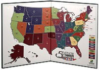
Fifty State Commemorative Quarter Map We've looked at all of the Coin Maps that are being advertised. Perhaps you have too. This is the best one we have seen by a long shot.
|
|||

U.S. Mint 50 State Quarters P&D (5 Page-Album) 1999-2008 H.E. Harris and Company, US Mint Brand Albums are made of archival-safe materials and provide rich historical details about specific denominations. State Series Quarters; 100 openings for both Philadelphia and Denver minted quarters. |
|||

Statehood Quarter Album (Official Whitman Coin Folder) Strong, soil resistant albums are designed with thumb notches for easy window removal. Every album features a trademark grained leatherette cover. Statehood Quarters Album 1999-2008 has 50 openings. |
|||

Kid's Statehood Quarters Collectors Folder: With Information on Collecting Other Cool Coins! The Kid's Statehood Quarter Collector's Folder has fifty coin slots--one for each of the fifty states--so you can store your Statehood Quarter collection in a safe, fun way. This folder also includes a 32-page booklet that will tell you:
NOTE: Coin slots are very tight. Coins are difficult to insert so be patient; tight slots means coins won't fall out. |
|||

The Shaping of America: A Geographical Perspective on 500 Years of History (Vol. 1: Atlantic America, 1492-1800), by D. W. Meinig. 528 pages. Publisher: Yale University Press (July 27, 1988) This entirely fresh interpretation of American history by a renowned historical geographer is the first in a projected three-volume series. Meinig here focuses on colonial America, examining how an immense diversity of ethnic and religious groups—Europeans, Africans, American Indians—ultimately created a set of distinct regional societies. Richly illustrated with more then forty specially prepared maps and contemporary illustrations, this volume prompts us to rethink the settling of North America. |
|||
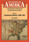
The Shaping of America: A Geographical Perspective on 500 Years of History (Vol. 2: Continental America, 1800-1867), by D. W. Meinig. 656 pages. Publisher: Yale University Press (February 22, 1995) In this volume, the second in a projected four-volume series, D. W. Meinig again provides a fresh interpretation of the American past, bringing his special geographical perspective to the years between 1800 and 1867, the period when the nation experienced a dramatic expansion in territory, population, economy, and political tension that culminated in the Civil War. As in his first volume, Atlantic America, Meinig assesses the characteristics of regions and political territories and the relations among them, examining the dual roles played by geopolitics and ethnoculture in the shaping of the United States. |
|||
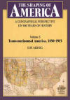
The Shaping of America: A Geographical Perspective on 500 Years of History (Vol. 3: Transcontinental America, 1850-1915), by D. W. Meinig. 480 pages. Publisher: Yale University Press (April 1, 2000) D. W. Meinig continues his riveting account of America’s interwoven history and geography, describing the expanding country’s development from the mid-nineteenth century to 1915. The book begins with the struggle over where to build the Pacific railway and fix the nation’s first transcontinental axis. Meinig portrays in detail the settlement of the diverse regions of the American West and how these many "Wests" were incorporated into the growing nation. He then examines the South as an imperial province and the dominance of the American Core over an increasingly consolidated nation. In conclusion, the Meinig considers America’s imperial pressures upon Canada and Mexico, the country’s overt expansions in the Caribbean and the Pacific, and the Panama Canal as a transcontinental completion. |
|||

The Shaping of America: A Geographical Perspective on 500 Years of History (Vol. 4: Global America, 1915-2000), by D. W. Meinig. 467 pages. Publisher: Yale University Press (October 25, 2006) This landmark book, the concluding volume in a magisterial series, presents the story of America’s interwoven history and geography from 1915 to 2000. Discussing such developments as the automotive, neotechnic, and communications revolutions, the world wars, urban migration, and regionalism, D.W. Meinig offers unprecedented insights into the reshaping of the United States. Winner of the 2005 John Brinckerhoff Jackson Prize sponsored by the Association of American Geographers Selected as an Outstanding Academic Title for 2006 by Choice Magazine. |
|||
 The Uniting States Benjamin F. Shearer The Uniting States: The Story of Statehood for the Fifty United States, by Benjamin F. Shearer. 1200 pages. Publisher: Greenwood (June 30, 2004) Fifty-one essays and over 90 maps tell the story of how each of the 50 states in the Union became part of, and remained, one nation, indivisible, over a span of 172 years. From Delaware's entry in 1787 through Hawaii's joining in 1959, The Uniting States brings together the unique stories of each of the 50 United States' journey into statehood in a single reference work. Local, national, and international matters loom large in this unique look at America's continent-spanning transformation from isolated English colonies to 50 distinct states. |
|||
[ HOME
| LINK TO NETSTATE
| GUESTBOOK
]
[ SPONSORSHIPS/ADVERTISING
| PRIVACY STATEMENT
| CONTACT US
]
Site designed exclusively for NETSTATE.COM by NSTATE, LLC

NETSTATE.COM is a Trademark of NSTATE, LLC.
Copyright © by NSTATE, LLC. All rights reserved.
No copyright is claimed on non-original or licensed material.
Support NETSTATE