Return to NETSTATE.COM home page.

|| HOME
|| INTRO
|| SYMBOLS
|| ALMANAC
|| ECONOMY
|| GEOGRAPHY
|| STATE MAPS
|| PEOPLE
|| GOVERNMENT
|| FORUM
|| NEWS
|| COOL SCHOOLS
|| STATE QUIZ
|| BOOK STORE
|| MARKETPLACE
|| STATE LINKS
|| GUESTBOOK
|| CONTACT US

South Dakota State Flag South Dakota

Bookmark and Share

The Geography of South Dakota

Click here  for a few definitions.

Longitude / Latitude Longitude: 97° 28' 33"W to 104° 3'W
Latitude: 42° 29' 30"N to 45° 56'N
South Dakota map
South Dakota base and elevation maps
Length x Width South Dakota is about 383 miles long (east to west) and 237 miles wide (north to south).  
Geographic Center
Explanation
The geographic center of South Dakota is located in Hughes County, 8 miles NE of Pierre.
Longitude: 100° 28.7'W
Latitude: 44° 24.1'N
 
Borders South Dakota is bordered by North Dakota on the north and by Nebraska on the south. On the east, South Dakota is bordered by Minnesota and Iowa. On the west, South Dakota is bordered by Montana and Wyoming.
Total Area South Dakota covers 77,121 square miles, making it the 17th largest of the 50 states.
Land Area 75,898 square miles of South Dakota are land areas.
Water Area 1,224 square miles of South Dakota are covered by water.
Highest Point The highest point in South Dakota is Harney Peak at 7,242 feet above sea level.
Lowest Point The lowest point in South Dakota is Big Stone Lake at 966 feet above sea level.
Mean Elevation The Mean Elevation of the state of South Dakota is 2,200 feet above sea level.
Major Rivers Cheyenne River, Missouri River, James River, White River
Major Lakes Lake Oahe, Lake Francis Case, Lewis and Clark Lake

The Land

The Missouri River runs through the central part of South Dakota. To the east of the river, lie low hills and lakes formed by glaciers. Fertile farm country covers the area. To the west of the Missouri River, the land consists of deep canyons and rolling plains. South Dakota land regions
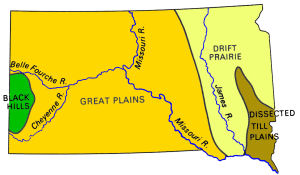
South Dakota Land Regions

South Dakota is comprised of four major land regions; the Drift Prairie, the Disected Till Plains, the Great Plains, and the Black Hills.

The Drift Prairie covers most of eastern South Dakota. This is the land of low hills and glacial lakes. This area was called Coteau des Prairies (Prairie Hills) by early French traders. In the north, the Coteau des Prairies is bordered on the east by the Minnesota River Valley and on the west by the James River Basin. The James River Basin is mostly flat land, following the flow of the James River through South Dakota from north to south.

The Dissected Till Plains lie in the southeastern corner of South Dakota. This area of rolling Hills is criss-crossed by many streams.

The Great Plains cover most of the western 2/3 of South Dakota. The Coteau de Missouri hills and valleys lie between the James River Basin of the Drift Prairie and the Missouri River. West of the Missouri River much landscape becomes more rugged and consists of rolling hills, plains, canyons, and steep flat-topped hills called buttes. These buttes sometimes rise 400 to 600 feet above the plains. In the south, east of The Black Hills, lie the South Dakota Badlands. Badlands National Park is located here.

The Black Hills are in the southwestern part of South Dakota and extend into Wyoming. This range of low mountains covers 6,000 square miles with mountains that rise from 2,000 to 4,000 feet high. The highest point in South Dakota, Harney Peak (7,242 feet above sea level), is in the Black Hills. The Black Hills are rich in minerals such as gold, silver, copper, and lead. The Homestake Mine, one of the largest gold mines in the in the United States, is located in the Black Hills. Here to are Mt. Rushmore, the Crazy Horse Memorial, and Wind Cave and Custer National Parks.

( South Dakota Close-up )

Climate (All temperatures Fahrenheit)
Highest Temperature The highest temperature recorded in South Dakota is 120°, Fahrenheit. This record high was recorded on July 5, 1936 at Gannvalley.
Lowest Temperature The lowest temperature in South Dakota, -58°, was recorded on February 17, 1936 at McIntosh.
Average Temperature Monthly average temperatures range from a high of 86.5 degrees to a low of 1.9 degrees.
Climate Average yearly precipitation for South Dakota, from 1971 to 2000, is shown on this chart from Oregon State University.
Sources:
The World Almanac of the U.S.A. by Allan Carpenter and Carl Provorse, Copyright © 1998
Edward Patrick Hogan, Sr. and John E. Miller, "South Dakota," World Book Online Americas Edition, http://www.worldbookonline.com/wbol/wbPage/na/ar/co/521180, August 15, 2001.
The United States Geological Survey Website
Maps.com http://www.maps.com
To South Carolina geography. To Tennessee geography.

[ HOME || INTRO || SYMBOLS || ALMANAC || ECONOMY || GEOGRAPHY || STATE MAPS || PEOPLE || GOVERNMENT ]
[ FORUM || NEWS || COOL SCHOOLS || STATE QUIZ || BOOK STORE || MARKETPLACE || STATE LINKS ]
|| GUESTBOOK || CONTACT US || PRIVACY STATEMENT ]

Site designed exclusively for NETSTATE.COM by NSTATE
United States Flag


NETSTATE.COM is a Trademark of NSTATE, LLC.
Copyright © 2001- by NSTATE, LLC. All rights reserved.
No copyright is claimed on non-original or licensed material.
Support NETSTATE

Top