Return to NETSTATE.COM home page.

|| HOME
|| INTRO
|| SYMBOLS
|| ALMANAC
|| ECONOMY
|| GEOGRAPHY
|| STATE MAPS
|| PEOPLE
|| GOVERNMENT
|| FORUM
|| NEWS
|| COOL SCHOOLS
|| STATE QUIZ
|| BOOK STORE
|| MARKETPLACE
|| STATE LINKS
|| GUESTBOOK
|| CONTACT US

Montana State Flag Montana

Bookmark and Share

The Geography of Montana

Click here  for a few definitions.

Longitude / Latitude Longitude: 104° 2'W to 116° 2'W
Latitude: 44° 26'N to 49°N
Montana map
Montana base and elevation maps
Greatest Dimensions Montana is about 559 miles from east to west and about 321 miles from north to south.  
Geographic Center
Explanation
The geographic center of Montana is located in Fergus County, 11 miles W of Lewistown.
Longitude: 109° 38.3'W
Latitude: 41° 1.9'N
 
Borders Montana is bordered by Canada on the north and by Idaho and Wyoming on the south. On the east, Montana is bordered by North and South Dakota and on the west Montana is bordered by Idaho.
Total Area Montana covers 147,046 square miles, making it the 4th largest of the 50 states right after Alaska, Texas, and California.
Land Area 145,556 square miles of Montana are land areas.
Water Area 1,490 square miles of Montana are covered by water.
Highest Point The highest point in Montana is Granite Peak at 12,799 feet above sea level.
Lowest Point The lowest point in Montana is the Kootenai River at 1,800 feet above sea level.
Mean Elevation The Mean Elevation of the state of Montana is 3,400 feet above sea level.
Major Rivers Clark Fork River, Missouri River, Yellowstone River
Major Lakes Flathead Lake, Fort Peck Lake

The Land

Montana can be divided into two geographic areas in general. The eastern 3/5 of Montana is covered by the Great Plains and the western 2/5 of Montana is the Rocky Mountain Region.

The Great Plains of Montana are part of the Interior Plain of North America that stretches from Canada south to Mexico. The Great Plains are made of high, gently rolling land interrupted by hills and wide river valleys including the Yellowstone and Missouri Rivers. Groups of mountains spring up from these plains; the Bear Paws, Big Snowy, Judith, and Little Rocky Mountains. In the southeast, badlands swept by wind and water showcase beautiful natural stone columns of red, yellow, brown, and white.

Hidden Lake, Glacier National Park, Montana
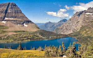
Hidden Lake - Glacier National Park

The Rocky Mountain Region of Montana is covered by flat, grassy valleys and mountains blanketed in fir, spruce, pine, and other evergreens. The southwest valleys are from 30 to 40 miles wide while the valleys in the north are narrower; from 1 to 5 miles wide. Many of the mountains are covered with snow for about 8 to 10 months of the year and a few active glaciers dwell in the higher altitudes. The Montana Rocky Mountains are known for their clear, cold lakes.

There are more than 50 mountain ranges in this region including the Absaroka, Beartooth, Beaverhead, Big Belt, Bitterroot, Bridger, Cabinet, Crazy, Flathead, Gallatin, Little Belt, Madison, Mission, Swan, and Tobacco Root ranges. Granite Peak, the highest point in Montana, rises 12, 799 feet above sea level in south-central Montana

Unfortunately, the Rocky Mountain Region is always in danger of earthquakes due to the faults that run through the area.

The Continental Divide, the place that separates waters running west into the Pacific Ocean and east to the Atlantic Ocean, runs through the Rocky Mountain Region. Montana is the only state that has rivers that drain into the Gulf of Mexico (Missouri River system), Hudson Bay (Bellys, St. Marys, and Waterton Rivers), and the Pacific Ocean (Columbia River system).

( Montana Close-up )

Climate (All temperatures Fahrenheit)
Highest Temperature The highest temperature recorded in Montana is 117°, Fahrenheit. This record high was recorded at Glendive on July 20, 1893 and at Medicine Lake on July 5, 1937.
Lowest Temperature The lowest temperature in Montana, -70°, was recorded on January 20, 1954 at Rogers Pass.
Average Temperature Monthly average temperatures range from a high of 86.6 degrees to a low of 8.1 degrees.
Climate Average yearly precipitation for Montana, from 1971 to 2000, is shown on this chart from Oregon State University.
Sources:
The World Almanac of the U.S.A. by Allan Carpenter and Carl Provorse, Copyright © 1998
Harry W. Fritz and Katherine Hansen, "Montana," World Book Online Americas Edition, http://www.worldbookonline.com/wbol/wbPage/na/ar/co/368920, August 15, 2001.
The United States Geological Survey Website
Maps.com http://www.maps.com
To Missouri geography. To Nebraska geography.

[ HOME || INTRO || SYMBOLS || ALMANAC || ECONOMY || GEOGRAPHY || STATE MAPS || PEOPLE || GOVERNMENT ]
[ FORUM || NEWS || COOL SCHOOLS || STATE QUIZ || BOOK STORE || MARKETPLACE || STATE LINKS ]
|| GUESTBOOK || CONTACT US || PRIVACY STATEMENT ]

Site designed exclusively for NETSTATE.COM by NSTATE
United States Flag


NETSTATE.COM is a Trademark of NSTATE, LLC.
Copyright © 2001- by NSTATE, LLC. All rights reserved.
No copyright is claimed on non-original or licensed material.
Support NETSTATE

Top