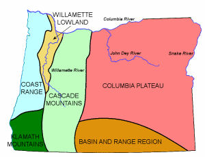
Return to NETSTATE.COM home page.

|| HOME
|| INTRO
|| SYMBOLS
|| ALMANAC
|| ECONOMY
|| GEOGRAPHY
|| STATE MAPS
|| PEOPLE
|| FORUM
|| NEWS
|| COOL SCHOOLS
|| STATE QUIZ
|| BOOK STORE
|| MARKETPLACE
|| STATE LINKS
|| GUESTBOOK
|| CONTACT US

Oregon State Flag Oregon

Bookmark and Share

The Geography of Oregon

Click here  for a few definitions.

Longitude / Latitude Longitude: 116° 45'W to 124° 30'W
Latitude: 42°N to 46° 15'N
Oregon map
Oregon base and elevation maps
Length x Width Oregon is about 401 miles from east to west and 294 miles from north to south.  
Geographic Center
Explanation
The geographic center of Oregon is located in Crook County, 25 miles SSE of Prineville.
Longitude: 120° 58.7'W
Latitude: 43° 52.1'N
 
Borders Oregon is bordered by Washington on the north and California and Nevada on the south. On the east, Oregon is bordered by Idaho and on the west, Oregon is bordered by the Pacific Ocean.
Total Area Oregon covers 98,386 square miles, making it the 9th largest of the 50 states.
Land Area 96,003 square miles of Oregon are land areas.
Water Area 2,383 square miles of Oregon are covered by water.
Highest Point The highest point in Oregon is Mount Hood, at 11,239 feet above sea level.
Lowest Point The lowest point in Oregon is sea level where Oregon meets the Pacific Ocean.
Mean Elevation The Mean Elevation of the state of Oregon is 3,300 feet above sea level.
Major Rivers Columbia River, Deschutes, Willamette River, John Day River, Snake River
Major Lakes Upper Klamath Lake, Crater Lake

The Land

Oregon Land Forms
Oregon Land Regions
Oregon is known for its forests where about 1/10 of the nation's timber resides. In fact, Oregon is the leading provider of lumber in the United States.

Oregon's geography can be divided into six areas; the Coast Range, the Willamette Lowland, the Cascade Mountains, the Klamath Mountains, the Columbia Plateau, and the Basin and Range Region.

The Coast Range runs from north to south along the Pacific Ocean. Much of these low mountain ranges are forested with evergreens such as Spruce, Fir, and Hemlock. The average mountaintop in the Coast Range rises less than 2,000 feet above sea level, though Mary's Peak, southwest of Corvallis, Oregon, reaches 4,097 feet above sea level. Along the coast, cliffs rise almost 1,000 feet high over the Pacific Ocean. The Triangle Lake Valley was a very ancient lake. Many small coastal lakes are scattered throughout the Coast Range.

The Willamette Lowlands are a narrow strip of land to the east of the Coast Range along the Willamette River. The Willamette River flows north into the Columbia River. The soil is rich in the Willamette Lowlands and the climate is mild.

To the east of the Willamette Lowlands, the Cascade Mountains rise to 11,239 feet above sea level (Mount Hood). The Cascade Mountains provide a rugged landscape where many of the nation's highest peaks can be found. Mount Hood is the highest point in Oregon. Other high peaks include Mt. Jefferson at 10,497 feet above sea level, Three Sisters, over 10,000 feet above sea level, and Mount McLoughlin, 9,495 feet high. Many lakes can be found in the Cascade Mountains. Crater Lake is the deepest lake in the United States. It's 1,932 feet deep!

In the southwest corner of Oregon are the Klamath Mountains. The Klamath Mountains are covered by dense forests.

Covering most of eastern Oregon and extending into Idaho and Washington, is the Columbia Plateau. Thousands of years ago, the Columbia Plateau was formed by lava flowing from cracks in the earth's crust. Oregon's Wheat farms are found on the Columbia Plateau. Much of the Columbia Plateau is quite rugged, however, and mountains such as the Blue Mountains and the Wallowa Mountains rise in the northeast. On the Oregon/Idaho border the Snake River has cut Hells Canyon deep into the earth. The average depth of this gorge, located between the Wallowa Mountains and the Seven Devils Mountains in Idaho, is 5,500 feet.

The Basin and Range Region covers a section of southeastern Oregon. The Basin and Range Region in Oregon is marked by high basins and a few steep mountains. Much of this region is semi desert.

( Oregon Close-up )

Climate (All temperatures Fahrenheit)
Highest Temperature The highest temperature recorded in Oregon is 119°, Fahrenheit. This record high was recorded on August 10, 1898 at Pendleton.
Lowest Temperature The lowest temperature in Oregon, -54°, was recorded on February 10, 1933 at Seneca.
Average Temperature Monthly average temperatures range from a high of 82.6 degrees to a low of 32.8 degrees.
Climate Average yearly precipitation for Oregon, from 1971 to 2000, is shown on this chart from Oregon State University.
Sources:
"Oregon." The World Book Encyclopedia. N-O Volume 14. Chicago: 1988.
The World Almanac of the U.S.A. by Allan Carpenter and Carl Provorse, Copyright © 1998.
Claude W. Curran and Gordon B. Dodds, "Oregon," World Book Online Americas Edition, http://www.worldbookonline.com/wbol/wbPage/na/ar/co/405160, August 15, 2001.
The United States Geological Survey Website
Maps.comhttp://www.maps.com
To Oklahoma geography. To Pennsylvania geography.

[ HOME || INTRO || SYMBOLS || ALMANAC || ECONOMY || GEOGRAPHY || STATE MAPS || PEOPLE ]
[ FORUM || NEWS || COOL SCHOOLS || STATE QUIZ || BOOK STORE || MARKETPLACE || STATE LINKS ]
|| GUESTBOOK || CONTACT US || PRIVACY STATEMENT ]

Site designed exclusively for NETSTATE.COM by NSTATE
United States Flag


NETSTATE.COM is a Trademark of NSTATE, LLC.
Copyright © 2001- by NSTATE, LLC. All rights reserved.
No copyright is claimed on non-original or licensed material.
Support NETSTATE

Top