
| Suggest a link | |
| Report broken link |


Tennessee Base and Elevation Maps
The two maps shown here are digital base and elevation maps of Tennessee. Higher resolution maps like
these and many other digital maps, wall maps, custom radius maps, travel maps, travel guides, map software, and globes and
games, for business and the classroom, are available to purchase from
Maps.com - The World's Largest Maps Store!.
Enter code "NETSTATE" at checkout for 10% off orders of $50 or more!
 |
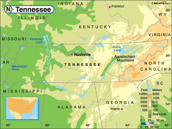
This Tennessee base map highlights the location of the state capitol, Nashville, and major cities throughout the state. Portions of Tennessee's border states, Kentucky, Virginia, North Carolina, Georgia, Alabama, Mississippi, Arkansas, Missouri, and Mississippi are included to show the relationship between Tennessee and its neighbors. A small inset shows Tennessee among the other 47 Continental United States. |
| Tennessee base map, Courtesy of Maps.com. |
|
 |
This elevation map of Tennessee illustrates the number of feet or meters the
state rises above sea level. The high points in the state are in the east along the border with Virginia and
North Carolina. The lower points are in the west along the Mississippi River. In fact, the lowest point in the
state is along the Mississippi River; 178 feet above sea level.
The highest point in the state is located near the North Carolina border in the Great Smoky Mountains National Park. As well as holding the title to the highest point in Tennessee, Clingman's Dome, at 6,643 feet above sea level is also the highest peak in the National Park and the highest peak on the Appalachian Trail. It's located in Sevier County, about 23 miles south of Gatlinburg. [ Topographic Map ] |
| Tennessee elevation map, Courtesy of Maps.com. |
Additional information
Tennessee maps: Additional maps and map links from NETSTATE.COM.
Tennessee geography: More Tennessee geography from NETSTATE.COM.
Purchase Tennessee maps:
Maps.com - The World's Largest Maps Store!
- Select map type by clicking on "category" to left on destination page.
- Use code NETSTATE at the checkout for 10% off orders of $50 or more!
- Over 6,000 products to choose from!
Site designed exclusively for NETSTATE.COM by NSTATE, LLC

NETSTATE.COM is a Trademark of NSTATE, LLC.
Copyright © © by NSTATE, LLC. All rights reserved.
No copyright is claimed on non-original or licensed material.
Support NETSTATE