
| Suggest a link | |
| Report broken link |


Idaho Base and Elevation Maps
The two maps shown here are digital base and elevation maps of Idaho. Higher resolution maps like
these and many other digital maps, wall maps, custom radius maps, travel maps, travel guides, map software, and globes and
games, for business and the classroom, are available to purchase from
Maps.com - The World's Largest Maps Store!.
Enter code "NETSTATE" at checkout for 10% off orders of $50 or more!
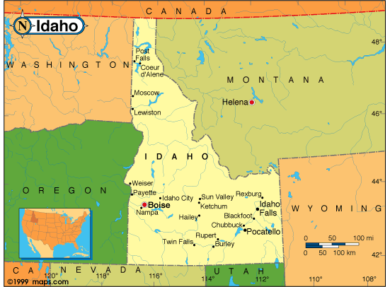 |
This Idaho base map highlights the location of the state capitol, Boise, and other majore cities within the state. Portions of Idaho's border states, Montana, Wyoming, Utah, Nevada, Oregon, and Washington are included to show the relationship between Idaho and its neighbors. Idaho is bordered by Canada on the north. A small inset shows Idaho among the other 47 Continental United States. |
| Idaho base map, Courtesy of Maps.com. |
|
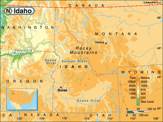 |
This elevation map of Idaho illustrates the number of feet or meters the
state rises above sea level. As you can see, most of Idaho resides at over 2,000 feet above sea level. The
mean elevation of Idaho is 5,000 feet above sea level.
The lowest point in Idaho is in Nez Perce County, at the Snake River, on the state's western border. This low point is 710 feet above sea level. The highest point in the state is located on the eastern side of the state near the Montana Border. Borah Peak, at 12,662 feet above sea level is located in Custer County about 44 miles northeast of Sun Valley. It's found in the Challis National Forest and is part of the Lost River Range of the northern Rocky Mountains. |
| Idaho elevation map, Courtesy of Maps.com. |
Additional information
Idaho maps: Additional maps and map links from NETSTATE.COM.
Idaho geography: More Idaho geography from NETSTATE.COM.
State elevations: State elevations listed by mean elevation, state high point and state low point.
Purchase Idaho maps:
Maps.com - The World's Largest Maps Store!
- Select map type by clicking on "category" to left on destination page.
- Use code NETSTATE at the checkout for 10% off orders of $50 or more!
- Over 6,000 products to choose from!
Site designed exclusively for NETSTATE.COM by NSTATE, LLC

NETSTATE.COM is a Trademark of NSTATE, LLC.
Copyright © © by NSTATE, LLC. All rights reserved.
No copyright is claimed on non-original or licensed material.
Support NETSTATE