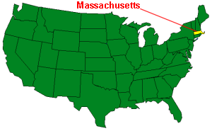
| Massachusetts is characterized by a jagged indented coast from Rhode Island
around Cape Cod. The land rises upward to the west with stony upland pastures
in the central part of Massachusetts and gentle hill country in the west.
Though the state is only about 190 miles long, from east to west, it is
comprised of six specific land regions; the Coastal Lowlands, the Eastern
New England Upland, the Connecticut Valley Lowland, the Western New England
Lowland, the Berkshire Valley, and the Taconic Mountains.
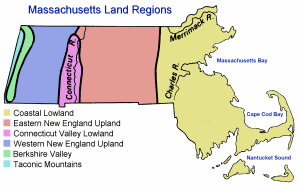 Coastal Lowland: The Coastal lowlands start in the east at the
Atlantic Ocean and include the Elizabeth Islands,
Martha's Vineyard,
and
Nantucket
Islands. The landscape is characterized by rounded hills, swamps, small lakes and ponds, and short, shallow
streams and rivers.
Yesterday's Island
Coastal Lowland: The Coastal lowlands start in the east at the
Atlantic Ocean and include the Elizabeth Islands,
Martha's Vineyard,
and
Nantucket
Islands. The landscape is characterized by rounded hills, swamps, small lakes and ponds, and short, shallow
streams and rivers.
Yesterday's Island
Eastern New England Upland: Further to the west, lies the Eastern New
England Upland area of Massachusetts. This area spreads westward from the Coastal
Lowlands forty to sixty miles, rising to about 1,000 feet above sea level and, then,
gradually sloping downward in the west to meet the Connecticut Valley Lowland. The
Eastern New England Upland actually extends from Maine to New Jersey and is
considered an extended part of the White Mountains of New Hampshire.
Connecticut Valley Lowland: The Connecticut Valley Lowland is a long,
narrow land area that extends from northern Massachusetts to southern Connecticut.
The Connecticut River runs through this area providing fertile soil for farming.
In Massachusetts the Connecticut Valley Lowland is about 20 miles wide.
Western New England Upland: This land area runs from Vermont through
Massachusetts down into Connecticut and is an extension of the Green Mountains
of Vermont. The land in this area rises in elevation from the Connecticut Valley
to heights of over 2,000 feet above sea level. Twenty to thirty miles wide in
Massachusetts, the Western New England Upland is home to the Berkshire Hills and
Mount Greylock, the highest point in Massachusetts at 3,487 feet above sea level.
Berkshire Valley: To the west of the Western New England Upland and the Berkshire Hills lies the Berkshire Valley. This narrow valley, less than ten miles
wide, runs between the Berkshire Hills to the east and the Taconic Mountains to the
west. The valley is covered with green meadowlands.
Taconic Mountains: On the extreme western border of Massachusetts lie
the Taconic Mountains. Less than six miles wide, this narrow band of hills
stretches from northwestern Massachusetts to the south rising upward to Mt.
Everett 2,602 feet above sea level.
( Massachusetts Close-up ) |


;)